


Defining and Displaying Google Maps from Lisp
The program at the bottom of the page (which uses Common Graphics on either Windows or Linux) shows how to use lisp to display a set of street addresses and/or other geographical locations together in a Google map. (The code is available for download here.) The lisp code does this by writing HTML text that contains JavaScript code into a file, and then displaying that file in an HTML browser. The JavaScript code calls functions in the Google Maps API to create the map, which is then displayed in a Common Graphics HTML widget. (On Linux a third-party HTML browser will be used instead of a Common Graphics widget.)
Once you have loaded the code, a simple lisp form like this one will display a map:
(display-addresses '(("Franz Headquarters"
                      "555 12th Street, Oakland, CA 94607")
                     ("Berkeley Bowl Marketplace"
                      "2020 Oregon Street, Berkeley, CA 94703")
                     ("Nifty Trails on the Hill"
                      37.8643 -122.241)))
The map is displayed below. Franz Inc. World Headquarters is near the bottom. The grocery store is in the middle, and a nice place to walk is toward the right.
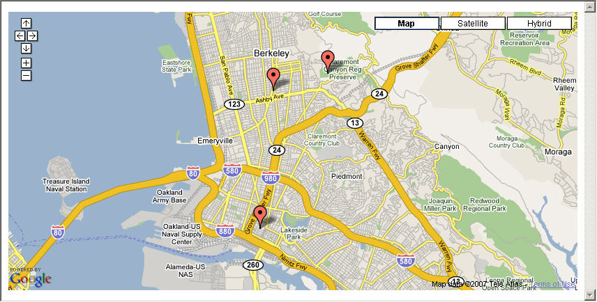
The first two entries in the example are street addresses while the third specifies a latitude and longitude directly. The first string in every entry is a label to display when the user moves the mouse cursor over the marker for that location. When a street address (or a more general indicator such as "Oakland, CA") is specified, a Google service is used to convert the address to a latitude and longitude. The set of all requested locations will be centered in the map, and the maximum zoom level that can display all locations simultaneously will be used.
Go ahead and place the program code below into a file and compile and load it (or simply evaluate it). (The code can also be downloaded from here.) Then evaluate the example call above. The HTML Browser window displayed above should appear and display the map.
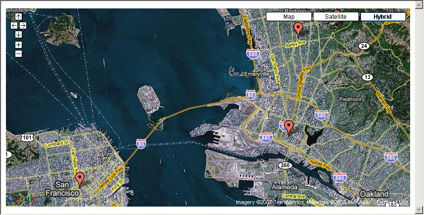
Here's a second example that adds an entry for the whole city of San Francisco. When you evaluate this form, notice how the map will automatically be zoomed farther out in order to encompass the broader range of locations. This example shows a "hybrid" map that combines features of the street and satellite views.
(display-addresses '(("Franz Headquarters"
                      "555 12th Street, Oakland, CA 94607")
                     ("Berkeley Bowl Marketplace"
                      "2020 Oregon Street, Berkeley, CA 94703")
                     ("The City" "San Francisco")
                     ("Nifty Trails on the Hill"
                      37.8643 -122.241))
                   :map-type :hybrid)
Here is the resulting map:
This last example shows only a single location, and initially shows the satellite view. Displaying only a single location causes it to zoom in as far as possible.
(display-addresses '(("Nifty Trails on the Hill"
                      37.8643 -122.241))
                   :map-type :satellite)
Here is the satellite map:

Now try some addresses of your own!
If you want to try adding other Google Maps features to this code, the Google Maps API is documented here: http://code.google.com/apis/maps/documentation/.
Here is the code. It can also be downloaded from here.
(in-package :cg-user)

;;; Here is a Google Maps API key that was generated for the franz.com domain.
;;; Apparently any valid key will work when reading a local HTML file as this
;;; example does, but if you adapt this code to serve the HTML on the web
;;; then you will need to replace this value with a Google Maps API key that
;;; you generate for the web server that is used.  Generate your own key here:
;;; http://code.google.com/apis/maps/signup.html

(defparameter *google-maps-api-key*
  "ABQIAAAAb4zVQYoi1pjhn-cgIfxB8xTIvawiYadrDEtGjIWCNEOmar7GXhR5GQqhs8xqs7rKUvYMLVDfGjiarg")

;;; ------------------------------
;;; Beginning of Web Page Skeleton

;;; This is a large format string that provides the skeleton of a
;;; web page with JavaScript that will be loaded into the HTML browser.
;;; This web page skeleton comprises most of this example code.

(defparameter *google-maps-javascript-skeleton*
  "<html><head><title>Google Maps Script</title>

<!-- This small script loads the Google Maps code and validates the key.
     The lisp code will fill in the actual key.  -->
<script src=\"http://maps.google.com/maps?file=api&v=2.x&~
              key=~a\"
        type=\"text/javascript\"></script>

<!-- Beginning of Google Maps JavaScript.  Most of this web page is
     JavaScript that uses the Google Maps API to display a map. -->
<script type=\"text/javascript\">

// A couple of objects to create once at load time.
var defaultIcon = new GIcon (G_DEFAULT_ICON);
var geocoder = new GClientGeocoder();

// Some global variables.
var minLat
var maxLat
var minLng
var maxLng
var markerCount

// This JavaScript function is called when this HTML page is
// loaded, due to the onload attribute of the body element below.
function initialize() {
    if (GBrowserIsCompatible()) {

        // Create a map and show it in the map_canvas HTML element
        // that's in the static HTML below.
        var map = new GMap2 (document.getElementById ('map_canvas'));

        // Google Maps requires that we set the map's center position
        // right off the bat, though later we will change the center
        // to be the midpoint of all marked locations.
        map.setCenter (new GLatLng (0, 0));

        // Set the map type (street, satellite, or hybrid).
        // The lisp code will fill in the requested type.
        map.setMapType (~a);

        // Enable zooming with the mouse's scroll wheel.
        map.enableScrollWheelZoom();

        // Add the standard Google Maps navigation control.
        map.addControl (new GSmallMapControl());

        // Add buttons for changing the type of map that is viewed.
        map.addControl (new GMapTypeControl());

        // Add markers for a set of locations.
        addAddresses (map, 12);
    };
};

function addAddresses (map) {
  minLat = 90.0
  maxLat = -90.0
  minLng = 180.0
  maxLng = -180

  // The lisp code will add a call here to addAddress for
  // each address that is requested in lisp, or a call to
  // addPlace for each explicit latitude and longitude.
  ~a
  }

function addAddress (map, address, label) {

  // Ask Google for the latitude and longitude of an address,
  // and then call addPlace to mark that location.
  geocoder.getLatLng (
    address,

    // Google will return the coordinates asynchronously, so
    // we must pass this callback function that performs anything
    // that must be done after the coordinates are known.
    function (point) {
      if (!point) {
        alert (address + \" not found\");
      }
      else {

        addPlace (map, point.lat(), point.lng(),
                       (label + \"<br>\" + address));

      }
    }
  );
}

function addPlace (map, lat, lng, label) {

    // Create a marker for a particular lattitude and longitude.
    var point = new GLatLng (lat, lng);
    var marker = new GMarker (point, { defaultIcon : defaultIcon });

    // Show an info window whenever the user moves the mouse cursor
    // over a location marker, and close the info window when they
    // move off the map entirely.
    GEvent.addListener (marker, \"mouseover\", function () {
        map.openInfoWindowHtml (point, (label + \"<br>\"
                                        + \"Lat \" + lat
                                        + \"     Lng \" + lng));
    });
    GEvent.addListener (map, \"mouseout\", function () {
        map.closeInfoWindow ();
    });

    // Add the new marker to the map.
    map.addOverlay (marker);

    // Remember the range of coordinates that have been marked
    // so that we can make the map encompass all of them.
    minLat = Math.min (minLat, lat);
    maxLat = Math.max (maxLat, lat);
    minLng = Math.min (minLng, lng);
    maxLng = Math.max (maxLng, lng);

    // Recenter the map to the middle of all locations that
    // we have marked so far.
    map.setCenter (new GLatLng ((minLat + maxLat) / 2,
                                (minLng + maxLng) / 2));

    // Find the maximum zoom level at which all of the requested addresses
    // will fit into the map (with a bit of margin), and zoom the map to
    // that level.  Note that it doesn't seem to work to specify the
    // corners of the bounding box when creating the GLatLngBounds
    // object, so we need to use the alternate approach of calling the
    // extend method instead.
    var bounds = new GLatLngBounds;
    bounds.extend (new GLatLng (minLat - ((maxLat - minLat) / 12),
                                minLng - ((maxLng - minLng) / 12)));
    bounds.extend (new GLatLng (maxLat + ((maxLat - minLat) / 12),
                                maxLng + ((maxLng - minLng) / 12)));
    map.setZoom (map.getBoundsZoomLevel (bounds));
};

</script></head>

<!-- End of JavaScript -->

<!-- When this web page is loaded, call our initialize function. -->
<body onload=\"initialize()\" onunload=\"GUnload()\">

<!-- This HTML element will be filled in with a map object that
     the JavaScript above creates. -->
<div id=\"map_canvas\" style=\"width: 100%; height: 100%\"></div>

</body></html>
")

;;; End of Web Page Skeleton
;;; ------------------------
;;; Beginning of Lisp Code

(defun display-addresses
    (locations &key
               (map-type :street) ;; or :satellite or :hybrid

               ;; If you have an html-widget on a custom dialog,
               ;; you could pass the widget here.
               #-gtk
               (html-browser-or-widget
                (html-browser :owner (ide:main-ide-window)
                              :exterior (make-box 0 0 900 700))))

  ;; The is the user-callable entry-point function.
  ;; It takes a list of location descriptors and adds hardcoded calls
  ;; into a JavaScript file to mark each location on a map.

  ;; Each entry in the locations list should be a list
  ;; containing a label to display for location followed by either
  ;; an address string or a latitude number and a longitude number.

  ;; Generate a JavaScript program into an HTML file.
  (let* ((javascript-path (merge-pathnames "temp-google-maps-script.html"
                                           (sys:temporary-directory))))
    (with-open-file (out javascript-path
                         :direction :output :if-exists :supersede)
      (format out *google-maps-javascript-skeleton*

        ;; Insert the Google Maps API key into the JavaScript skeleton.
        *google-maps-api-key*

        ;; Insert the requested map type into the JavaScript skeleton.
        (case map-type
          (:street "G_NORMAL_MAP")
          (:satellite "G_SATELLITE_MAP")
          (:hybrid "G_HYBRID_MAP"))

        ;; Insert calls to addAddress and addPlace into the JavaScript skeleton.
        (with-output-to-string (string-out)
          (dolist (entry locations)

            ;; Make sure each entry is of one of the valid forms.
            (unless (and (consp entry)
                         (cdr entry)
                         (not (cdddr entry))
                         (stringp (first entry))
                         (if* (cddr entry)
                            then (and (realp (second entry))
                                      (realp (third entry)))
                            else (stringp (second entry))))
              (pop-up-message-dialog
               (screen *system*) "Bad Location Value"
               (format nil "Each location must be a list consisting of either ~
                            a label string and an address string or else ~
                            a label string, a latitude number, and a ~
                            longitude number.  The following entry does ~
                            not match:~%~%~s"
                 entry)
               error-icon "~OK")
              (return-from display-addresses))

            ;; If an entry has a third member, then it specifies
            ;; a latitude and longitude directly.
            (if* (cddr entry)
               then (format string-out "  addPlace (map, ~a, ~a, ~s);~%"
                      (second entry)(third entry)(first entry))

                    ;; Otherwise it specifies an address.
               else (format string-out "  addAddress (map, ~s, ~s);~%"
                      (second entry)(first entry)))))))

    ;; Maybe display the generated JavaScript file in the editor
    ;; so you can see the code that was generated.
    ;; Warning:  If this file was already in the editor, this will
    ;; not update it, so you'll need to use File | Revert to Saved.
    #+maybe
    (ed javascript-path)

    ;; Display the Google map in an HTML widget.  This requires
    ;; Common Graphics (and the IDE if the owner of the browser
    ;; is an IDE window, as it is with the default argument value).
    #-gtk
    (progn
      (display-html html-browser-or-widget javascript-path)
      (select-window (typecase html-browser-or-widget
                       (html-browser html-browser-or-widget)
                       (html-widget (owner html-browser-or-widget)))))

    ;; On GTK the Mozilla GTK widget is likely not installed,
    ;; so display the map in Firefox if available, and otherwise
    ;; simply post the pathname on the clipboard for the user to
    ;; paste into some third-party HTML browser.
    #+gtk
    (invoke-private-html-browser javascript-path)))

;;; End of Lisp Code
;;; ----------------
| Copyright © Franz Inc., All Rights Reserved | Privacy Statement | 
|

|

|

|

|